Staring at Mount Pleasant listings and seeing words like deepwater, tidal creek, or marshfront? If you love the Lowcountry, those terms matter for your boat access, permits, and long-term value. You want clear, practical guidance before you fall for a view or a dock photo. This guide explains the most common Charleston-area waterfront terms in plain English, with Mount Pleasant examples and a checklist you can use today. Let’s dive in.
Deepwater: what it really means
Deepwater typically means you have year-round navigable depth with dependable access to a maintained channel or the harbor without frequent grounding at low tide. In practice, that can support larger powerboats and yachts and gives you more flexible boating windows.
Deepwater lots often allow docks with walk-down slips or lifts for bigger vessels. You still need permits for any structure, but you may avoid repeated dredging if you sit near a maintained channel.
Deepwater usually commands a price premium because it offers easier docking and broader boating options. In Mount Pleasant, properties on parts of the Wando River and along Charleston Harbor channels are commonly described as deepwater.
Tidal creeks: charm and tradeoffs
Tidal creeks are smaller, winding waterways that rise and fall with the tide. Depth can shift seasonally or after storms. These waters are great for kayaks, paddleboards, shallow-draft skiffs, and scenic wildlife viewing.
Some creeks are navigable for larger boats only around certain tides. Permits for docks are common, but dock length and depth can be limited. Dredging is tightly controlled and not always feasible.
Shem Creek is a good local example. It is lively, with restaurants, small marinas, and many docks. It shows how a tidal creek can be active and fun but not the same as deepwater for large vessels.
Intracoastal access from Mount Pleasant
The Atlantic Intracoastal Waterway is a protected route that runs along the coast. Having easy access to the Intracoastal opens up comfortable cruising and longer trips between marinas in different towns.
From Mount Pleasant, boats reach harbor routes and the Intracoastal through the Wando River and the Charleston Harbor complex. The convenience for your specific lot depends on the distance and approach to a maintained channel.
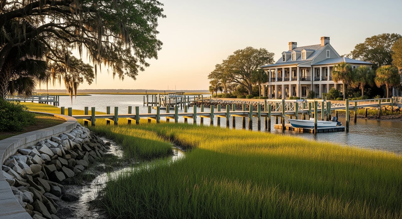
Marshfront lots: views and realities
Marshfront means your land borders vegetated tidal marsh rather than an open water channel. The views, wildlife, and privacy can be outstanding.
Direct boat access is not guaranteed. You may need a long dock to reach a navigable cut, and some sites simply are not dockable. Shoreline work on marshes is viewed closely by regulators, and living shorelines are often preferred over bulkheads.
Marshfront resells well for scenery-focused buyers, but it is not a substitute for deepwater if you plan to keep a larger boat at home.
Dockable water: how to verify
Dockable water means the adjacent water has enough depth and legal permission for a private dock you can use regularly. Dockable is not the same as deepwater.
Assessment depends on several factors:
- Depth at mean low tide where your boat would pass and tie up
- Distance and path to a maintained channel, including any shoals
- Local and state permitting rules for dock length, pilings, and lifts
- HOA covenants that limit dock designs or lift types
- Habitat such as seagrass or wetlands that affect design or location
Dockable lots tend to be valued higher than non-dockable marshfronts. The premium reflects the boat size you can actually use and the cost and complexity of getting a dock permitted and built.
Canalfront: access with shared upkeep
Canalfront property sits on a man-made canal intended to provide dock access for each lot. Depth may be more uniform, especially right after development.
Over time, many canals shoal and need periodic dredging. Maintenance is often handled by the HOA, and fees or special assessments can apply. The predictability is attractive, but factor in shared upkeep.
Water views without water access
Some properties offer elevated or panoramic views of marsh, river, or harbor without touching navigable water. These homes are appealing if you want scenery and lower maintenance.
You will not have dock rights, but you also avoid many permitting and maintenance tasks. For daily boating, you would use a nearby public ramp or marina instead.
Permits and agencies: who does what
Even if a property had a dock before, you must confirm current permits and rules. Expect to work with several layers of oversight depending on your plan.
- Town of Mount Pleasant: local zoning and approvals for shoreline structures
- South Carolina DHEC Office of Ocean and Coastal Resource Management (OCRM): state authorization for docks, bulkheads, and work seaward of mean high water
- U.S. Army Corps of Engineers (USACE): federal permits for work in navigable waters and dredging
- FEMA/NFIP: flood zones, elevation certificates, and insurance requirements
- South Carolina Department of Natural Resources (SCDNR): habitat and fisheries considerations, including seagrass
- HOA or neighborhood authority: private covenants for docks, lifts, and shared waterways
Beyond permits, know that the state generally holds title to tidal submerged lands under public trust principles. You have riparian access rights, but not ownership of the navigable channel or submerged bottom.
Physical factors that shape use and value
Tides and daily usability
Tidal swing controls how much water you have at low tide and when you can move a deeper-draft boat. Ask for tide datums used by surveyors and learn your low-tide depths at the dock face and along the approach.
A practical rule is to plan for your boat’s draft plus a reasonable safety clearance. Confirm with a recent depth survey and local practice for your stretch of water.
Shoaling and dredging
Creeks and lateral cuts often shift with storms and seasons. Even if you are near a maintained channel, the short stretch from your dock to that channel can shoal.
Private dredging needs federal and state authorization and can be costly. Public or federal dredging does not guarantee that small private approaches stay clear.
Storms, flooding, and sea-level rise
The Charleston region experiences tidal flooding and storm surge. Elevation, structural design, and insurance are core to your long-term plan.
Lower sites or exposed locations may have higher maintenance and insurance costs. Elevated construction and resilient shoreline choices are common in the area.
Shore protection and habitat
Shoreline options include living shorelines using marsh plantings or sills and harder structures such as bulkheads or riprap. Regulators often prefer living shoreline methods to support habitat.
Seagrass beds and marsh habitat can limit dock footprints and drive design choices like open piles to reduce shading.
Mooring vs slip vs lift vs marina
- Mooring your boat can be cost-effective but less convenient for loading and maintenance.
- A private slip offers convenience but requires permits and ongoing care.
- Boat lifts keep hulls cleaner and reduce growth, but designs must fit local rules and avoid excess shading.
- Marinas provide services for a monthly fee and can be ideal if you want less on-site upkeep.
Due diligence checklist you can use now
Gather these items early in your process to avoid surprises:
- Current property survey showing mean high and low water lines, wetlands, and elevations
- Deed and title details on riparian rights or easements
- Copies of dock, pier, or shoreline permits and any prior denials
- Recent low-tide photos at the proposed dock location
- A recent bathymetric or sonar depth survey for the dock approach
- HOA bylaws covering docks, lifts, dredging, and slip policies
- FEMA flood map for the parcel and any elevation certificate
Ask these practical questions:
- Is there an existing dock? Was it permitted, and under which permit number and date?
- What is the low-tide depth at the dock face and along the approach? Is there a survey?
- How far is the nearest maintained channel, and are there known shoals between?
- Who maintains the channel and shoreline? Is dredging federal, county, HOA, or private?
- Are there seagrass beds, oyster reefs, or protected habitat on site?
- Does the HOA have a shared dock policy, dredging schedule, or special assessments?
- What is the flood zone, and what are typical insurance premiums nearby?
- Are there no-wake zones, speed limits, or heavy boat traffic patterns to factor in?
Budget categories to research:
- Application fees and required studies for permits
- Dock construction, lifts, and periodic maintenance
- Potential private dredging costs and frequency
- Flood, wind, hurricane, and boat insurance
- Time from application to permit based on scope and agency load
Scenarios and smart next steps
- If you want to keep a 25 to 30 foot powerboat at home year-round, focus on verified deepwater or dockable lots with recent low-tide depth data and a short approach to a maintained channel.
- If your priority is serene views and paddle days, a marshfront or tidal creek lot can offer lower upkeep and beautiful outlooks.
- If you prefer convenience with services, compare nearby marinas on Shem Creek or the Wando River rather than owning a private dock.
Before you make an offer, verify permits, ask for recent depth information, and review HOA covenants. A clear picture upfront protects your boating plans and your resale value.
Ready to map your options around Mount Pleasant’s creeks, rivers, and harbor access? Schedule a personalized consultation with Lisa Nicole Thornton to align your waterfront goals with the right property and due diligence plan.
FAQs
What does “deepwater” mean in Mount Pleasant?
- Deepwater generally means reliable, year-round navigable depth with access to a maintained channel or the harbor, supporting larger boats without frequent low-tide grounding.
Can you build a dock on a marshfront lot?
- Sometimes, but it depends on depth, habitat, design limits, and permits from local and state agencies; some sites are not dockable even if they have great views.
How do tides affect boating on tidal creeks?
- Tides control low-tide depth and windows for moving deeper-draft boats, so you should confirm depths at the dock face and along the approach with recent surveys.
Who maintains dredging for canals or private approaches?
- Federal or state entities maintain major channels, while canals and private approaches are typically the responsibility of HOAs or private owners if permitted.
What flood and insurance issues should waterfront buyers expect?
- Flood zones, elevation requirements, and storm exposure affect design and premiums, so check FEMA maps, elevation certificates, and local insurance history early.
Are Shem Creek properties considered deepwater?
- Shem Creek is a tidal creek with mixed uses and many docks, but it is not universally deepwater for large vessels; suitability depends on depth and tides at each site.
