Water shapes daily life on James Island. If you picture coffee on the porch as the tide rolls in or quick hops to the harbor by boat, the right waterfront setting makes all the difference. This guide breaks down how riverfront, tidal-creek, marshfront, and community-access homes work, what to know about docks and permits, and the flood and maintenance factors that should be in your budget. You will come away ready to match your lifestyle to the right shoreline and ask the smart questions before you write an offer. Let’s dive in.
Waterfront types on James Island
Riverfront deepwater
Frontage on main channels like the Stono River offers longer views, deeper water, and more direct runs to Charleston Harbor and the Atlantic. This is where you see larger docks or community deepwater piers and a boating lifestyle geared toward bigger center consoles and cruisers. For trip planning and to confirm depths or bridge clearances, consult official NOAA nautical charts.
Private docks on deeper water are often feasible, but they must comply with state rules on size, location, and navigation. Boat lifts, pierheads, and pilings require permits under South Carolina’s coastal program, and boathouses are typically restricted. You will also see elevated coastal homes that meet flood design standards, plus more exposure to salt and wind, which increases upkeep on metal, paint, and mechanicals.
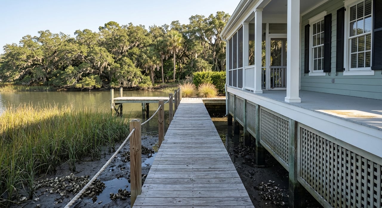
Tidal-creek frontage
Creekfront homes line scenic tidal channels that meander through the marsh. You get wildlife and quiet water, plus excellent paddling and inshore fishing. These creeks can be shallower, so larger boats may be tide dependent. Dock footprints and boat sizes are commonly limited by creek width and state rules that protect navigation and the marsh. In narrower creeks, joint or community docks are a frequent solution.
Expect longer walkways to reach navigable water and plan for tidal timing if you keep a boat at home. At certain low tides, you might choose kayaks or skiffs over deeper-draft vessels for stress-free access.
Marshfront
Marshfront homes sit at the edge of the salt marsh with broad, ever-changing views and strong privacy. Many lots prioritize the view rather than direct deepwater moorage. Some marshfront parcels can support a long walkway and dock to the first navigable creek, but others cannot meet frontage or width tests for a private dock under state standards. Nature-based shoreline solutions are increasingly encouraged; learn more about best practices in regional living shoreline guidance.
Houses are typically elevated Lowcountry styles with big porches and screened rooms that frame the marsh. Because marshes do not block storm surge from open channels, pay close attention to flood elevation, construction details, and insurance.
Interior homes with community water access
Several neighborhoods offer community docks, ramps, lagoons, or shared deepwater access. You get the water lifestyle without private dock maintenance. HOAs may manage dock rules, storage, and fees. Always confirm recorded rights of use and any Dock Master Plan that governs how many slips and what vessel types are allowed.
Boating access and marinas
Public landings make a big difference in how often you get on the water. Battery Island Landing on James Island is an example of a local access project that enhances Stono River reach for residents and visitors. Explore the Battery Island Landing project to get a sense of public ramp amenities on the island.
Full-service marinas nearby provide fuel, pump-outs, slips, and service yards. Before assuming availability, verify services and transient slips using the state’s marina directory. Currents can run strong in some corridors, so time your launches and returns with tides and consult NOAA nautical charts for channel soundings and hazards.
Dock permits and shoreline rules
Understanding permits early prevents surprises in due diligence. In South Carolina, docks, bulkheads, and similar structures in tidelands and coastal waters require approvals under the state OCRM program. Key practical points frequently shape feasibility and design:
- For many post-regulation lots, a private dock often requires about 75 feet of marsh frontage and 75 feet between extended property lines. Joint-use docks can sometimes work with about 50 feet per lot.
- Creek width governs whether private docks are allowed at all and how large pierheads and floats may be.
- Docks must not impede navigation, and structures typically must rest over water at low tide.
You can review statutory context in the South Carolina coastal management code via state citations compiled here. In platted neighborhoods, recorded subdivisions or Dock Master Plans may create different, grandfathered rights. Always request existing permits, plats, and recorded documents during diligence.
Flood zones, elevation, and insurance
Most waterfront parcels sit in FEMA Special Flood Hazard Areas. Lenders often require flood insurance, and elevation strongly influences premiums. Start with FEMA’s Flood Map Service Center to locate the current effective map panel and zone, then ask for the seller’s Elevation Certificate and any Letters of Map Change.
Within Charleston city limits, new construction and substantial improvements must meet local flood design standards, including base flood elevation plus freeboard and, where applicable, V-zone or Coastal A guidance. The city outlines documentation and permitting expectations for building in flood zones in its flood construction guidance. Plan your inspections and insurance quotes early, then discuss coverage options with your lender and insurance professional.
Utilities: sewer or septic
James Island includes a patchwork of public sewer and on-site septic. Sewer availability can affect renovation feasibility, insurance underwriting, and long-term maintenance costs. Confirm service with a current availability letter and request records for any existing septic system. Start with Charleston Water System resources to understand service areas and next steps.
Shoreline stabilization options
Hard bulkheads can protect some sites but often come with environmental and permitting tradeoffs. State and regional policies increasingly favor nature-based solutions where conditions allow. Oyster reef sills and vegetated buffers reduce erosion while supporting habitat and water quality, and they may align better with today’s regulatory priorities. Explore regional living shoreline guidance to understand design concepts you may encounter in permits and HOA rules.
Pricing drivers and tradeoffs
On James Island, waterfront premiums typically reflect a mix of depth and access, elevation, view corridor, dock rights, and proximity to ramps or marinas. Deepwater frontage with an approved private dock often commands the highest prices. Higher-elevation homes can be more attractive to buyers who prioritize lower flood-risk profiles. Shoreline protection, whether bulkhead or nature-based, can also influence value and maintenance planning.
Annual ownership costs tend to be higher on the water. Budget for dock and lift servicing, pierhead and walkway repairs, shoreline maintenance, and added wear from salt and wind on exterior systems. The City of Charleston’s planning work also tracks increasing nuisance and high-tide flooding over time, which is useful context when you estimate long-term carrying costs. Review the city’s flooding and sea level rise strategy to understand local adaptation priorities.
Neighborhood snapshots
- Seaside Plantation and Freeman’s Point: Planned neighborhoods with marsh views and shared water access such as community docks or ramps. A fit if you want the water lifestyle without full private-dock maintenance.
- Stiles Point Plantation: Established areas with segments offering broad views toward the harbor and downtown. Expect a higher-end subset of homes and lots where view corridors drive value.
- Bennett’s Bluff: Newer construction with marshfront settings and private dock opportunities that connect to local creeks and broader river systems.
- Riverland Terrace and Riverbend: Older neighborhoods with public-landings access and varied housing styles. Good examples of tidal-creek proximity and convenient trailering to ramps.
Buyer due diligence checklist
Use this short list to keep your offer strong and your surprises low:
- Verify FEMA zone, map panel, and effective date, and request the Elevation Certificate and any past flood-claim history.
- Ask for existing OCRM dock permits, recorded plats, or a Dock Master Plan, and confirm eligibility for a private dock based on frontage and creek width.
- Confirm water depth at low tide where a dock or float would sit, referencing NOAA charts and, if needed, a local survey.
- Determine utility status: public sewer or septic. If septic, obtain inspection reports and permit history. If sewer, request a service-availability letter.
- Review shoreline stabilization: bulkhead age and permits or any nature-based systems. Clarify who pays for maintenance.
- Obtain flood insurance quotes based on the current Elevation Certificate and confirm any lender-specific conditions for waterfront properties.
How to match lifestyle to shoreline
- If you want quick runs to the harbor in a larger boat: focus on riverfront deepwater with confirmed depth and existing dock permits.
- If your ideal day is kayaking at sunrise and watching herons from the porch: look at tidal-creek or marshfront, and plan around tide timing.
- If you want lower maintenance with water access: consider interior homes in communities with recorded dock and ramp rights.
When you narrow to a few streets or creeks, we will layer in elevation data, permit records, and HOA documents so your offers reflect both lifestyle and risk.
Ready to explore your best fit on James Island’s waterfronts? Let’s map the shoreline types to your goals, then target the homes where permits, elevation, and budget align. Schedule a personalized consultation with Lisa Nicole Thornton to start your plan.
FAQs
What are the main waterfront types on James Island?
- Riverfront deepwater, tidal-creek frontage, marshfront, and interior homes with community docks or ramps.
How do I know if a lot can have a private dock?
- Check state OCRM rules on frontage and creek width, ask for existing permits or a Dock Master Plan, and verify navigation depth at low tide.
Do I need flood insurance for a James Island waterfront home?
- Most waterfront parcels fall in FEMA Special Flood Hazard Areas, so lenders often require flood insurance based on the Elevation Certificate.
What should I budget for dock ownership?
- Plan for inspections, lift servicing, pierhead and walkway upkeep, and periodic repairs from salt, wind, and marine wear.
Are living shorelines allowed on James Island?
- Yes, regulators increasingly favor nature-based stabilization where site conditions support it, often reviewed during the shoreline permit process.
Where can I find marina services near James Island?
- Use the state’s marina directory to confirm fuel, slips, pump-outs, and service availability before assuming full service.
